
Satellite images are taken by reconnaissance satellites that orbit the Earth at a relatively low altitude, between 300 to 600 miles (or 480 to 970 km). As the majority of today's satellites are custom made in order to accommodate particular needs of the designer, there is no standard on which photo imagery is based on but the principle remains the same. Given the costs of creating and putting a satellite into orbit they tend to have highly specialized functions, as an example, reconnaissance satellites that are used to provide satellite Read More
Medium Earth Orbit
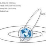
Medium Earth Orbit (MEO) refers to a satellite which orbits the earth at an altitude below 22,300 miles (geostationary orbit) and above the altitude of Low Earth Orbit (LEO) satellites. Medium Earth Orbit represents a series of tradeoffs between geostationary orbit (GEO) and Low Earth Orbit (LEO). Medium Earth Orbit enables a satellite provider to cover the earth with fewer satellites than Low Earth Orbit, but requires more satellites to do so that geostationary orbit. Medium Earth Orbit terrestrial terminals can be of lower power and use smaller antennas than Read More
Linear LNB
LNB stands for low noise blocker and it is essentially an amplifier on the end of your small satellite TV dish or communications dish. The “Linear” portion of Linear LNB stands for the characteristics of the radio waves that are transmitted via the satellite in space to your dish (LNB). Two Types of Polarization Circular Polarization Circular polarization is a characteristic of radio waves that are transmitted from a satellite in space, in which the actual radio waves rotate in a spiral. The spiral of radio waves either rotates clockwise Read More
C Band
C Band is the original frequency allocation for communications satellites. C-Band uses 3.7-4.2GHz for downlink and 5.925-6.425Ghz for uplink. The lower frequencies that C Band uses perform better under adverse weather conditions than the Ku band or Ka band frequencies. C Band Variants Slight C Band frequency variations are approved for use in various parts of the world. Band TX Frequency RX Frequency Extended C Band 5.850 – 6.425 GHz 3.625 – 4.200 GHz Super Extended C-Band 5.850 – 6.725 GHz 3.400 – 4.200 GHz INSAT C-Band 6.725 – 7.025 Read More
Weather Satellite

A weather satellite is a satellite which is used by meteorologists to gather information about the weather. Weather satellites give meteorologists a view of weather patterns over a very large area. This enables meteorologists to track large weather patterns and make more accurate predictions of future weather behavior. In addition to visual monitoring, weather satellites may also use thermal imaging, X-ray sensors, high-energy proton detectors, alpha detectors, and energetic particle sensors. Weather satellites travel in either geostationary or polar orbits. Weather satellites in geostationary orbits provide views of the same Read More
Reed-Solomon

Reed-Solomon is an algorithm for Forward Error Correction (FEC). Reed-Solomon was introduced by Irving S. Reed and Gustave Solomon of MIT Labs in Polynomial Codes Over Certain Finite Fields, which was published in the Journal of the Society for Industrial and Applied Mathematics in 1960. Reed-Solomon does not specify a block size or a specific number of check symbols. These variables can be set to the best variables for each transmission medium. DVB uses Reed Solomon coding configured to use blocks of 188 information symbols and 16 check symbols, which Read More
Inclination
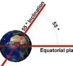
Inclination is the angle between a satellite orbit and the equator. Inclination is measured as the angle at which the satellite crosses the equator while passing from the southern hemisphere to the northern hemisphere. A satellite travelling in a geostationary obit will have an inclination of zero. Inclination is between 0 and 90 degrees for satellites in non-retrograde orbits, and between 90 and 180 degrees for satellites in retrograde orbits. A satellite in a polar orbit will have an inclination of exactly 90 degree. A satellite with an inclination of Read More
Feedhorn

The feedhorn is the part of a satellite dish system which gathers the reflected signal from the dish and focuses it towards the LNB. It is a type of horn antenna that is deployed to convey radio signals between the transceiver and the reflector antenna. Horn antennas basically effect a transition between waves propagating through a transmission line like a waveguide and the waves propagating in free space. The shapes could be various, based on the final purpose of regulating some of the fundamental properties of gain, radiation pattern and Read More
Azimuth

Azimuth is a measurement at an angle used in the spherical coordinate system. To find a point of interest, the observer creates a vector that is then projected in a perpendicular fashion onto a reference plane. The resulting angle between the projected vector and the reference vector located on the reference plane is the azimuth. It is the direction on the reference plane that is used to determine where the point of interest lies in the spherical coordinate system. A common use of the azimuth measurement is to find the Read More
Ku Band
The Ku band (Kurtz-under band) is primarily used for satellite communications, particularly for editing and broadcasting satellite television. This band is split into multiple segments broken down into geographical regions, as the ITU (International Telecommunication Union) determines. The Ku band is a portion of the electromagnetic spectrum in the microwave range of frequencies ranging from 11.7 to 12.7GHz. (downlink frequencies) and 14 to 14.5GHz (uplink frequencies). The most common Ku band digital reception format is DVB (main profile video format) vs the studio profile digital video format or the full-blown Read More
Share on: